At A Glance:
-
The Challenge
The terrain and tropical weather of South Africa’s eThekwini Municipality (including City of Durban) contribute to frequent, devastating flooding. The local government needs an early flood warning system to prevent loss of life and costly infrastructure damage.
-
The Solution
Environmental observation company Obscape utilized Iridium Connected® product RockBLOCK by our partner Ground Control to build a flood prediction and preparation disaster management solution.
-
The Impact
RockBLOCK enabled real-time environmental observations and forecasts, which are instrumental in predicting catastrophic tropical storms, alerting local authorities, and assisting in understanding and mitigating flood-related issues.
- 150 water management devices deployed
- $0licensing fee for data portal use
- #1container port in Africa
The Challenge
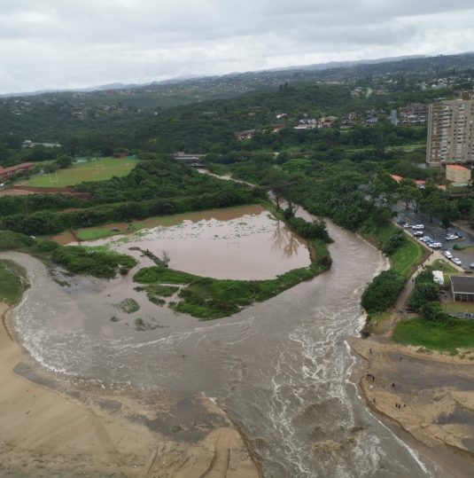
Durban is famous for its iconic beachfront and for being the largest container port in the Southern Hemisphere. However, tucked in a complex river delta with 17 estuaries and exposed to tropical cyclones and heavy rainfall, the eThekwini Municipality constantly battles floods. The problem is exacerbated by climate change, accelerated sea level rise, and human-induced land subsidence.
After devastating floods in 2017 and 2019 resulted in massive economic damage, human displacement, and loss of life, the eThekwini initiated a new disaster management strategy to better prepare for future crises. The local government identified the need for real-time environmental observations and forecasts for flood prediction and preparation. They researched the installation and maintenance of a network of weather monitoring stations but faced a few obstacles. First, the existing solutions were too expensive. Second, the available instrumentation was cumbersome and easy to spot—making it vulnerable to theft. Third, available multichannel dataloggers with several wired external sensors weren’t robust enough for a massive disaster management program. Lastly, data were hard to gather and analyze without a centralized portal.
The government considered using point-to-point radio and LORA communication, but both were cost prohibitive and logistically complicated. Also, some flood-prone areas were outside the city or further offshore–making satellite communications imperative.
The Solution
The municipality partnered with Obscape, a Netherlands-based environmental monitoring equipment manufacturer, to deploy Flood Early Warning Systems (FEWS) along the coastline to monitor storms and rising sea levels.
Obscape worked with Iridium partner Ground Control to create affordable yet robust solar-powered, wireless turnkey equipment to collect long-term, actionable environmental data.
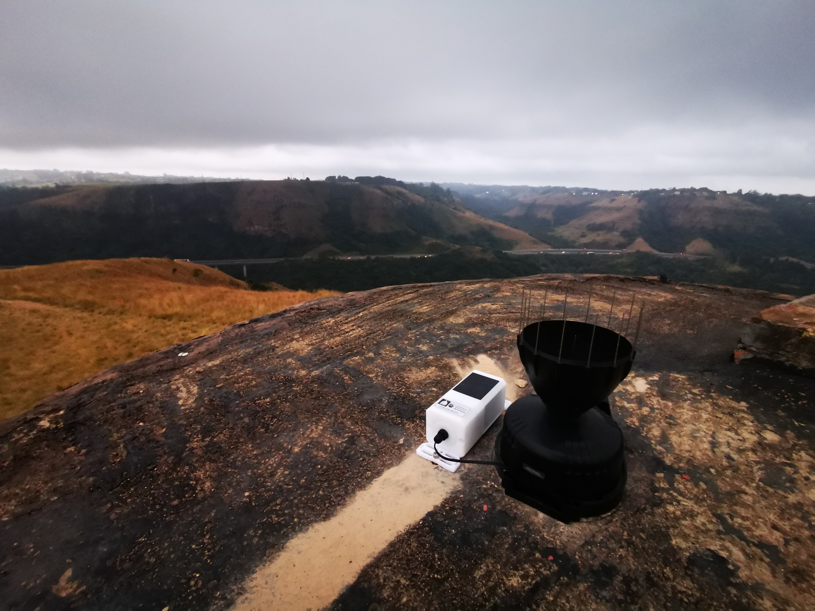
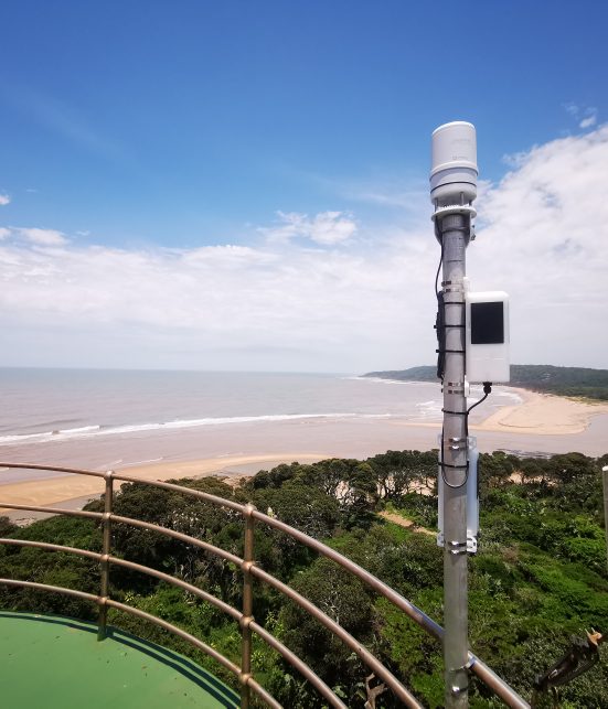
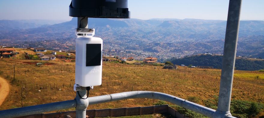
Obscape integrated Ground Control’s RockBLOCK modem, enabled by the built-in Iridium® 9603 satellite transceiver. The modem is at the heart of the Power Telemetry Module (PTM), an all-in-one datalogger and key component of the FEWS. The engineers mounted the systems above water on bridge decks, walls, trees, and poles near rivers in the flood hazard zones.
The Iridium 9603 transceiver allows for a small enclosure and discreet appearance. Shaped like a 1-liter milk carton, the FEWS device can serve as a time-lapse camera, rain-level gauge, and weather station, forming one monolithic piece without external cables, which makes it inconspicuous, but also robust.
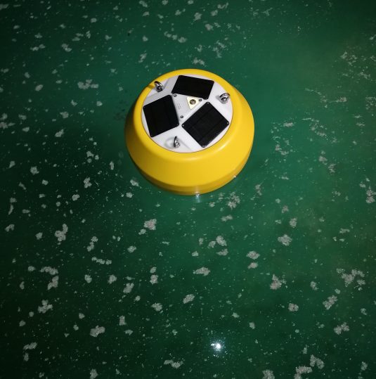
Another core monitoring system is the Iridium Connected wave buoy, which is equipped with sensors that detect wave height and direction – both important environmental data components. Thanks to the Iridium Short Burst Data® (SBD®) service, the FEWS provides critical, precise data to help water managers monitor flood-prone coastal areas, urban river corridors, and wetlands almost in real time. All data from the various measuring devices flow into a centralized portal, allowing seamless gathering and analysis.
The solution reduced municipality costs of sending field engineers to the monitoring sites, thus improving data-gathering efficiency.
The Impact
Today, the eThekwini Municipality environmental monitoring network consists of 150 stations, which will expand to 200 sites over time. The network contains four wave buoys, 25 water level gauges, 55 rain gauges, 28 time-lapse cameras,seven weather stations, and more–covering 2,297 km2 (approximately 887 square miles).
Thanks to the Iridium Connected solution, eThekwini can receive threshold alerts and predictive environmental markers visualized in downloadable reports. The data allow the municipality to identify potential forecast patterns, which enable targeted responses to protect residents and safely manage port operations.
The eThekwini municipality is pleased to continue to utilize the Iridium Connected RockBLOCK devices as they enable a low total cost of ownership, reliability, resilience, ease of installation and operation, data accuracy and security, and quality assurance.
“Iridium’s low-cost and small form-factor transceivers allowed us to make the FEWS so affordable that we can set up a bigger measurement network and collect more crucial environmental data,” Radermacher said. “In fact, our wave buoy is 5-10% of the cost of traditional measuring buoys. When you make the equipment accessible and easy to use, you can start to collect data, understand the problem, and come up with potential solutions to improve the quality of life in those places.”
““The collected data play an important role for fighting calamities. Maintenance of the systems has been extremely low since the first Power Telemetry Module devices were installed at the start of 2020. None of the devices experienced serious fouling of sensors or solar panels, and data transmission through the Iridium network has been stable. Any setting adjustments or firmware upgrades could be simply made over the air via the Iridium network.”
–Max Radermacher,
Obscape Director
Want more info?
Get In Touch With Our Team